Homepage ServoVision Map Link to Contact US.

AeroCop Hybrid HB

GENERAL The autonomous industrial unmanned hybrid helicopter HB has been developed for professional airborne applications such as aerial mapping, airborne broadcasting, search & rescue, surveillance and inspection as well as law enforcement.

Comes with special motor KollMorgen from USA

COMING SOON!

Medium UAV Heli / gasoline engine or electric motor : Mini Unmanned Helicopter
BASIC FEATURES

Rotor Span: 1.8 meters Length: 1.2 meters
Range: 20 Km Operational Altitude: 3600 ft Maximum Altitude: 12000 ft Endurance (Gasoline Engine/ Electric Motor): 90 / 35 Min

PAYLOAD
Day Camera System Thermal Camera System 2 Axis Stabilization System Precise Target Coordinate Estimation
GROUND CONTROL SYSTEM
Compact Design With Ruggedized Casing
Ruggedized Touch Screen Laptop PC
Membrane Button Panel Ground Control Unit HardwareMulti Function Joystick (Camera Controls, Flight Controls) Battery Unit,Real Time Video Decoder


AeroCop HB2
Autonomous Industrial Unmanned Helicopter

NewVersion

GENERAL The autonomous industrial unmanned helicopter AeroCop HB2 has been developed for professional airborne applications such as aerial mapping, airborne broadcasting, search & rescue, surveillance and inspection as well as law enforcement


AeroUAV Autonomous Industrial Unmanned Helicopter (ECO)

GENERAL /ecconomy Function The autonomous industrial unmanned helicopter Aero UAV-GRS260ZA has been developed for professional airborne applications such as aerial mapping, airborne broadcasting, search & rescue, surveillance , inspection , Aerial PhotoGraphy ,Vedio PhotoGraphy/Recording , Mapping GPS , VTOL applications , as well as law enforcement-DJI : Programmable Way point ,3D-stablilizer , navigator ,localization , on GPS googleMAP, with high perfromance &long range Transceiver and Data Link telemetry .- With OSD (On sereen display) remotecotrol FPV (first person view) : optional
- HDTV wireless camera (with or without pan & Tilt mechanism ) :,(optional),high resolution Video HDTV 1280 x 1024 Photography Via 2.4 - 5.8 Ghz Brooad Wide re blind -area , Compensable Technology And/or intelligent - Olfaction -Detection or Public wireless 3G (4G) networks
- Multiple user input GPS coordinates (Flight path) with Automatrically GPS tagged digital Photo.
- Predetermined interval GPS Flightpath with Digital photo : Optional Application for GIS (geographic information system) , INS/GPS ,Spatial Data IT & MIS.


  1. Military
  2. Law Enforcement and Homeland Security (HLS)
  3. Search & Rescue
  4. Power lines Inspection
  5. Gas Pipeline Inspection
  6. Geodesy & Geography
  7. Environmental Uses
  8. Agriculture

Rotary Unmanned Aerial Vehicle
In Operational UAV Gray Color

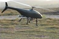
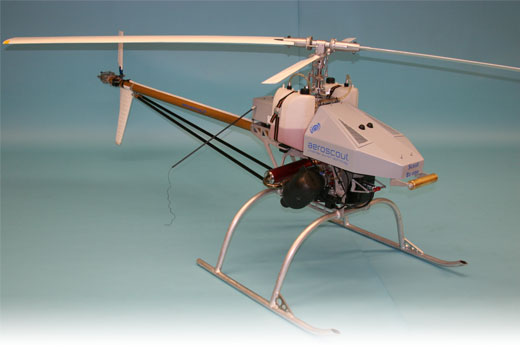
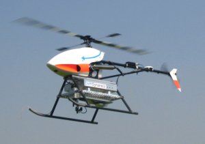
UAVs have already made their mark in revolutionizing the military in various fields like intelligence, surveillance and reconnaissance (ISR).


Both manned and unmanned aircrafts have been in use for military applications for years. While manned helicopters are used in all military areas, stabilization and navigating problems have hampered the use of unmanned helicopters. One of these areas is the introduction of rotorcraft in marine & navy applications. Unmanned helicopters are "perfect" for marine tasks, such as surveillance, observation, Electronic Warfare and more. Their advantage is the inherent characteristic of vertical take off and landing (VTOL).


Ground military forces can gain great advantages too, as UAV/VTOL rugged products are compact and mobile designed to meet military demands. From organized battalions to special operation units launching a RUAV from a backyard or rooftop, the support in battle is crucial.


An unmanned vehicle can enter danger zones where humans cannot walk or fear to be hit. This is true especially in areas hit by unconventional warfare, such as chemical and biological hazards. Scanning an area can be safely done without endangering human lives. A RUAV can hover at low altitudes using sensors custom for these type of missions.


Rotary Unmanned Aerial Vehicle (UAV) Following A Suspect

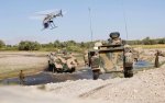
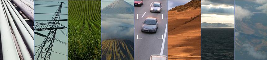
Often the most efficient method of law enforcement is achieved by viewing a situation from above. Indeed many police forces & Homeland Security agencies all over the world use manned helicopter units both in emergency and routine situations.

Presently, almost all airborne police tasks are carried out by manned helicopters equipped with visual cameras, IR sensors as well as powerful spotlights.

Major drawbacks associated with the use of these airborne units are:

  • High maintenance costs
  • Dependency on skilled crew and staff
  • Danger to vehicle and crew during violent events

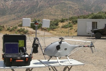
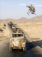
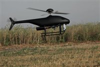
UAV/VTOL compact & mobile products are efficient and very useful for every law enforcement and homeland security task. Rotary UAVs have great advantages and can be suitable for stealth operations or regular patrols assisting other units from above, sending live video from the scene to the controller and to the unit's head quarters. From checking an object to laying an explosive device without endangering personal.


Rotary Unmanned Aerial Vehicle (UAV) , Long Range Application

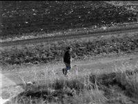
During search & rescue missions there is a need to cover as much of the area as rapidly as possible. Use of unmanned helicopters in such missions together with rescue teams may save time and lives. RUAVs can scan "hard to get to" terrain with various sensors and day/night cameras, without the need to endanger more lives. The system is compact and mobile, making it suitable for mobile search & rescue units. The ability to lift off and land anywhere (VTOL) is a necessity in difficult terrains. The ability to hover and move in all directions (position trimming) gives the ground viewer more time and ease to scan objects and track the required object.

Over the ocean it is very hard to scan without loosing orientation. The use of a rotary UAV with a GPS assures that little is missed and every spot is scanned. This is important for all terrains but especially difficult over the ocean where the view is monotonous and everything looks the same to the human eye.
It supports and prays for the people of Haiti and the search & rescue personal at this hard time of tragedy.


Power Line Aerial Photo Taken
Rotary Unmanned Aerial Vehicle
In Low Altitude Flight of 17 Meters
Flying About 50 Meters Away
Equipped with a Lev 2 Daytime Camera Payload

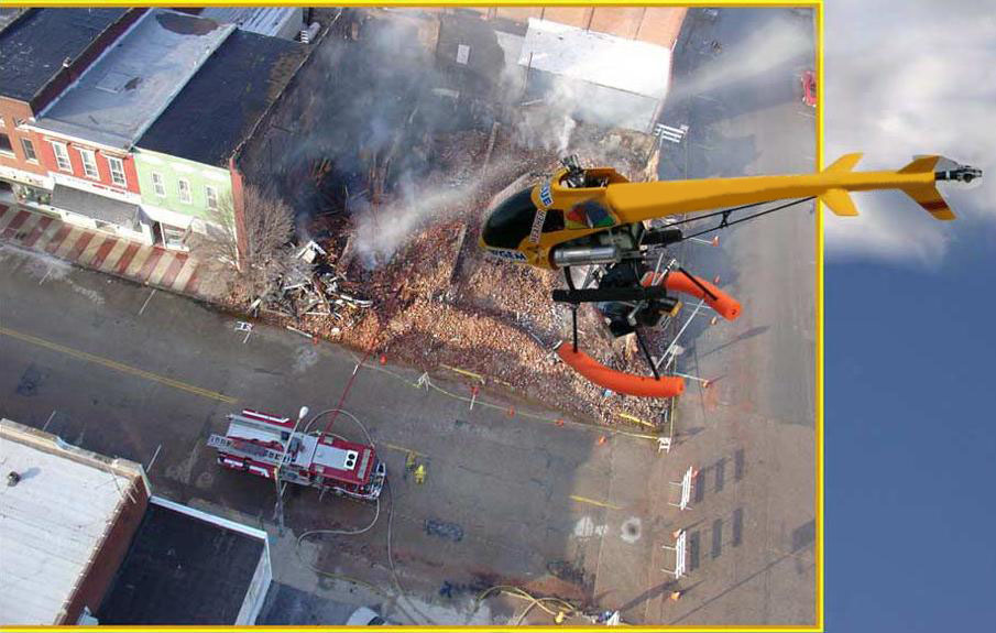
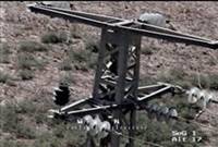
Power line inspection involves examining the pylons and their high voltage insulators. Even the conecting screw must be intact. This process is increasingly being performed by helicopters. Typically the smallest team is made up of an observer using dedicated equipment and a pilot flying at about 10-50 knots. The inspection frequency depends on transmission line size. The helicopter usually hovers at a horizontal distance close enough for observation, approximately 20-300 feet depending on the equipment used and at a height of about 15 feet from the ground. This means that the noise produced by the inspection limits the hours the helicopter can fly, due to noise abatement laws and disturbance to livestock.

Electricity providers in many countries commission the service of manned helicopter companies to conduct power line inspections, wash insulators and detect thermographic problems.

With the current economic climate where cost reduction plans are being drawn up, replacing this method of inspection should most certainly be examined. Especially today the technological advantage provided by Rotary UAVs may overcome past restraints.

UAS is very suitable for electric power line inspection tasks. Equipped with required cameras, an inspection of specific electric power lines and poles or wide range inspection sends real time footage and data to the operator which can be sent at the same time to the power company's control center for reviewing. Contact us for more up-to-date information. 


Rotary Unmanned Aerial Vehicle
In Low Altitude Flight

Pipeline infrastructures must constantly be monitored. The potential threat to lives and economic losses necessitates constant and regular inspections. Pipelines located near mines risk rupture due to land movement associated with underground mining.


Europe has invested in numerous projects using satellite based remote sensing (PRESENSE, PIPEMOD and GMOSS) to reach the levels of pipeline monitoring required by the pipeline operators, only to conclude that more work is necessary to reach the level needed by the pipeline operators.


Rotary UAV based can monitor and inspect gas and oil pipelines by flying and hovering at low altitude with special camera sensors. The footage is sent in real time to the ground operator for editing and assessing the pipe's condition.


Rotary Unmanned Aerial Vehicle
In Low Altitude Flight

Aircrafts are widely used for taking professional pictures from up above the ground. Mapping the landscape is an entire profession and is used by many industries and institutes. Cartography is an art going back to ancient days, but today it needs to produce the most accurate maps and GIS layers possible. Geodesy, the science of measuring the size, shape, and gravity field of the Earth requires exact measurements. Geography, the study of physical and human landscapes, the processes that affect them, how and why they change over time, and how and why they vary spatially, is used in many fields of industry, academy and research.

The state of the art Unmanned Aerial Systems (UAS) can give footage and exact measurements by using various payload sensors on an unmanned rotorcraft. Rotary UAVs have natural advantages which achieve the required tasks of these fields.


Rotary Unmanned Aerial Vehicle
Flying At High Altitudes

Earth observation and environmental monitoring involve numerous sub-topics. Unmanned aircraft hold a big role in this field. For example, in Japan a RUAV was used to monitor a volcano from the inside.


The rotary UAV have natural advantages over other platforms, such as its inherent flexibility both in hover and capacity. This comes in very useful for many Environmental researches and tasks.

UAV,VTOL has the ability to customise its products to fit the needs and custom payloads for a wide variety of tasks to help observe, study and keep our green planet.


Rotary Unmanned Aerial Vehicle
In Low Altitude Flight Over A Corn Field

Agriculture is still the world's largest industry. Expenditures on insecticides and herbicides account for a sizable percentage of a farmer’s operating expenses. Effective pesticide spraying is a crucial factor in farm profitability. Both over spraying and under spraying can have serious consequences. Farmers constantly seek improved methods for avoiding disease, insect infestation and weed damage.


While much of the world’s agriculture is dependent on chemical spraying, it is recognized by all as an environmental threat if not used wisely and sparingly. Many governments, especially in Canada and Europe are introducing or have introduced strict legislation pertaining to the use of pesticides and other agricultural chemicals.


Rotary UAVs have many advantages and are used for spraying crops and monitoring fields. Our products can improve crop yield and optimum harvest and improving agricultural land usage through sophisticated monitoring. Usages include wild and unwanted plant growth control, detection of optimal conditions for crop harvesting and pruning.


Is suited for a wide range of agricultural needs. RUAVs may be used for monitoring fisheries and for monitoring the spreading of sea weeds. RUAVs offer the ability to spray all around a weed exactly.


Video Surveillance

Motion Picture film work

Harbour Patrol

Communications Repeater 

Video Downlink Repeater

Incident Response

Fire Control

Light Cargo

Border Patrol

FLIR / Night Vision

SWAT Support

Earth Quake Damage Inspection

Imaging and Mapping

GPS / Telemetry

Search & Rescue

Radiation Measurement

Narcotics Sensors

Pipe Line Patrol

Law - Enforcement

Traffic Monitoring

Chemical / Weed Spraying

Mine Detection